Though I never really felt lost during the second leg of my trip, I suppose you could use the word to describe a few instances in it. After all, it's a word often used to describe a situation when you don't know what you're looking for, don't really know where you're at and can't rely on any previous information because you've never been there or know anyone who has.
Yeah, that's where I found myself a couple times during this leg, partly because Morocco's central corridor isn't given a lot of coverage in most travel books; partly because I just didn't know where we were. Regarding the former, this is probably because it's in the middle of everything; there are few extremes to note.
This area's main road is bookended by Marrakesh and Fes; its terrain isn't flat or mountainous. Vegetation isn't scarce, nor does is it provide the majority of the nation's bread basket. Residing between the nation's railroad tracks and the Atlas mountains keeps it away from most tourists' eyes, in the middle of nowhere.
...Unless you have your own vehicle, money for a rental or the patience for mass transportation, you'll miss a few of the central corridor's more impressive sites (click here for a map). For our trip, David and I drove most of the first afternoon through Marrakesh and its eastern foothills to Demnate and our first central site: its natural land bridge.
Getting the idea from a lesser-known - and pictureless - source, I didn't really know what to expect of this thing. In my mind, the "bridge" was probably one or two stones forming a natural arch the size of a vehicle or two. Maybe something like driving through a Redwood along the California coast. Regardless, we both knew the thing was located near a fork in the road past Demnate.
The signs were useless when we reached the fork, so we went right for a few miles. No luck. We returned then went left a similar stretch. Nothing. The third time we returned to the intersection we admitted man failure and asked directions of one of the locals sitting on the side of the road. We were informed that he saw us pass the landmark that we were now standing on twice. A quick peek over the previously unobserved railing confirmed our location - we were on the natural bridge.


Reaching our touristy fill for the day - and craving a bit of news regarding the particulars of Osama's fate (which we only learned about a day before) - we hitched up at a nearby bed and breakfast and settled in for some satellite news and beef Tajine. That night, I closed my eyes the first time a 34-year old, convinced I wouldn't have to worry about this "public terrorist number one" again.
They opened fresh for the day's drive to the "Cascades d'Ouzaid" (Waterfalls) through the Ait Begoumez valley to our south. The "Ait" is described as a hidden gem that no one sees because it's so removed from the rest of the country. A few sources likened it to driving through an impressionist painting where farmers stand under whipped-cream clouds and wave sickles through golden wheat husks. I also saw these images in the first half of the painting we drove through.


The rough paint brush I drove over in the second half of the painting overshadowed any impressionist sites, if any existed in the first place. Somewhere between 1500m of elevation and "are we still on the right road," pavement ended and slick mud replaced its unguarded "S" curves. Further eroding my confidence of knowing where we were, the "path" on my Garmin refused to get any closer to one of our turns for almost 45 minutes. "Happy valley," as most locals referred to it, was starting to piss me off.
Thankfully, my anger was only fueled by 15 minutes of white-knuckled driving before we picked up pavement again and a more pleasant view of the hikers' valley. Further, just as we rejoined the paved world, David informed me that one of his Peace Corps buddies lived in the area. Not able to resist the urge to tell him that, "we're just in the neighborhood and thought we'd stop by," we called and met up with the volunteer for some tea and a welcome reprieve from my muddy Chevy.


After the falls, we found the highway and rolled into a corner of the blue-collar town of Beni Mellal. Awaiting us was beer, intermittent sleep, and a winding, coasting, pin-balling ride through four more hours of travel to Fes the next day. Arriving in the Imperial city well ahead of schedule, I looked forward to the next leg of my trip, where the food was neither middle-of-the-road nor hard to find: Bologna, Italy.
Yeah, that's where I found myself a couple times during this leg, partly because Morocco's central corridor isn't given a lot of coverage in most travel books; partly because I just didn't know where we were. Regarding the former, this is probably because it's in the middle of everything; there are few extremes to note.
This area's main road is bookended by Marrakesh and Fes; its terrain isn't flat or mountainous. Vegetation isn't scarce, nor does is it provide the majority of the nation's bread basket. Residing between the nation's railroad tracks and the Atlas mountains keeps it away from most tourists' eyes, in the middle of nowhere.
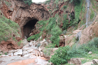
...Unless you have your own vehicle, money for a rental or the patience for mass transportation, you'll miss a few of the central corridor's more impressive sites (click here for a map). For our trip, David and I drove most of the first afternoon through Marrakesh and its eastern foothills to Demnate and our first central site: its natural land bridge.
Getting the idea from a lesser-known - and pictureless - source, I didn't really know what to expect of this thing. In my mind, the "bridge" was probably one or two stones forming a natural arch the size of a vehicle or two. Maybe something like driving through a Redwood along the California coast. Regardless, we both knew the thing was located near a fork in the road past Demnate.
The signs were useless when we reached the fork, so we went right for a few miles. No luck. We returned then went left a similar stretch. Nothing. The third time we returned to the intersection we admitted man failure and asked directions of one of the locals sitting on the side of the road. We were informed that he saw us pass the landmark that we were now standing on twice. A quick peek over the previously unobserved railing confirmed our location - we were on the natural bridge.

The Land Bridge measures over 4-stories high, sits beneath a paved road (barely visible above its two-story cavern) and hosts a couple waterfalls itself.

Stalactites hanging above the bridges rock-filled river.

The Interior
They opened fresh for the day's drive to the "Cascades d'Ouzaid" (Waterfalls) through the Ait Begoumez valley to our south. The "Ait" is described as a hidden gem that no one sees because it's so removed from the rest of the country. A few sources likened it to driving through an impressionist painting where farmers stand under whipped-cream clouds and wave sickles through golden wheat husks. I also saw these images in the first half of the painting we drove through.

Part of the Ait Begoumez farmland, where numerous collectives have begun in order to preserve the valley's cultural heritage and agricultural productivity.

Whipped clouds breezed on by.
Thankfully, my anger was only fueled by 15 minutes of white-knuckled driving before we picked up pavement again and a more pleasant view of the hikers' valley. Further, just as we rejoined the paved world, David informed me that one of his Peace Corps buddies lived in the area. Not able to resist the urge to tell him that, "we're just in the neighborhood and thought we'd stop by," we called and met up with the volunteer for some tea and a welcome reprieve from my muddy Chevy.

If the vehicle slid to the left a few feet, one - if not all - of the tires would replace gravel with air and significantly shorten our descent of the mountain range. Luckily, the rain that caused the current slickness ended more than two days before and was followed by clear, afternoon skies.
After an hour of spirited conversation, our drive continued into late afternoon and reached a spot we expected to find Ouzaid's waterfalls. Again not sure what to expect in terms of magnitude, we walked around the potential entry site until our manly pride collapsed and we were forced into asking an unofficial guide for help assistance. As before, our expectations - or at least mine - were exceeded.

Standing just under a football field high, the falls were the first to find the northern valley, now designated a national park.

Swimming in the pools below is prohibited, but most locals still spend summer days camped by the falls' depository.

The Barbary Ape in his natural habitat...

...and bridging the human - ape gap...

...to beg for food.

The northern view into the park, an old village resting in the middle of the forward spine.

Mist fills the late-afternoon air. Most tourist sites appear to be unmarked, forcing those interested to hire locals for directions and boost the economy.
After the falls, we found the highway and rolled into a corner of the blue-collar town of Beni Mellal. Awaiting us was beer, intermittent sleep, and a winding, coasting, pin-balling ride through four more hours of travel to Fes the next day. Arriving in the Imperial city well ahead of schedule, I looked forward to the next leg of my trip, where the food was neither middle-of-the-road nor hard to find: Bologna, Italy.
Lovely pics, esp. "whipped clouds" and the last one ("mist fills . . ."). Really, who would have thought the natural bridge would be under your feet, or under your wheels?!
ReplyDelete